Floodplain Ordinance
- Above the Flood: Elevating Your Floodprone House, FEMA-347 (2000)
- Answers to Questions About the National Flood Insurance Program, F-084 (2011)
- Coastal Construction Manual, FEMA-P-55, (2011)
- Elevated Residential Structures, FEMA-54 (1984)
- Protecting Manufactured Homes from Floods and Other Hazards, FEMA P-85 (2009)
- Mitigation of Flood and Erosion Damage to Residential Buildings in Coastal Areas, FEMA-257 (1994)
- Protecting Building Utilities From Flood Damage, FEMA-P-348 (1999)
- Protecting Floodplain Resources, FEMA-268 (1996)
- Reducing Damage from Localized Flooding, FEMA 511 (2005)
- Substantial Improvements/Substantial Damage Desk Reference, FEMA P-758 (2010)
What Is a Floodplain?
Floodplains are low-lying lands adjacent to waterways that are naturally subject to periodic flooding. Special development standards apply to those areas that have been designated as the “100-year floodplain.”
What Is the “100-Year Flood”?
Floodplain development regulations are based on the 100-year flood, which is more accurately described as the flood that has a 1% probability of being equaled or exceeded in any year. Engineering models are used to determine both the area subject to inundation and the height of floodwaters during this model flood event. The area that would be flooded is called the “Special Flood Hazard Area” and is subject to floodplain development regulations. The water height is called the “Base Flood Elevation” and is the basis for development standards within the regulated floodplain area.
The 100-year flood, or base flood, has a 1% probability of being equaled or exceeded in any given year. In some places, this flood has never occurred in recorded history. Other areas have experienced more than one “100-year flood” in a single year.
Where Do I Find a Flood Hazard Map?
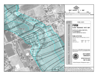
Regulated Special Flood Hazard Areas are delineated on Flood Insurance Rate Maps (FIRMs) issued by the Federal Emergency Management Agency (FEMA). In some municipalities additional maps (Flood Boundary and Floodway Maps) and/or a Flood Insurance Study provide additional information. These maps and studies are available from the County Building Inspection Office. The FIRM maps can also be viewed at FEMA’s online Map Service Center. The “Make a FIRMette” feature enables you to save or print a selected portion of a map along with identifying information.
What Can I Learn from a Flood Hazard Map?
Areas subject to floodplain development regulations are shaded areas labeled with the letter “A,” sometimes followed by a number or letter (or “V” in coastal areas). If Base Flood Elevations have been determined, they will be indicated on the map and in a Flood Insurance Study. “Floodway” areas may also be shown, either on the FIRM or on a separate Flood Boundary and Floodway Map. More stringent development controls apply within the regulatory floodway portion of the floodplain. The 500-year floodplain may be shown as a lightly shaded area labeled Zone B or Zone X. Although most municipalities do not impose special development standards within the 500-year floodplain, the flood hazard in these areas should be considered, particularly with regard to the location of critical facilities or storage of hazardous materials.
What Activities Are Regulated?
All development within the areas mapped as the 100-year floodplain (or Special Flood Hazard Area) is subject to floodplain development regulations. “Development” is defined as “any man-made change to improved or unimproved real estate” and includes (but is not limited to):
- the construction, reconstruction, renovation, repair, expansion, or alteration of buildings, accessory structures, or other structures;
- the placement of manufactured homes;
- mining;
- dredging;
- bridges, streets, and other paving;
- docks;
- utilities;
- filling, grading, and excavation;
- drilling operations;
- storage of equipment or materials; and
- installation of manufactured home, recreational vehicle, or trailer parks.
How Do I Get a Permit to develop in a floodplain?
Development in Special Flood Hazard Areas is regulated by the Santa Clara County Department of Planning and Development, which is responsible for issuing permits. In most cases, a Building or Grading Permit is required for all development in a floodplain.
What Are the Requirements for Floodplain Projects?
Minimum standards for floodplain development have been established by the federal government as a condition for the sale of federally subsidized flood insurance and eligibility for federal flood recovery assistance. Some states and communities have chosen to provide an extra margin of safety by exceeding the minimum federal standards.
The specific requirements for a floodplain development project depend on the flood zone and the type of development. The basic standards that must be met by any floodplain development are:
- Proposed development must be reasonably safe from flood damage, which for most buildings means elevated above the height of floodwaters.
- Proposed development shall not result in physical damage to any other property. Technical analysis may be required if there is potential for increased flood heights, diversion of flow, flotation of materials, or release of pollutants.
Applicant shall obtain any other required permits. Note that obtaining state or federal permits does not mean that floodplain requirements have been met – a project in the floodplain also requires a local floodplain development permit.
What Is Covered by Floodplain Regulations?
For the purpose of floodplain management, “development” is defined as any man-made change to improved or unimproved real estate. A floodplain development permit is thus required for a wide range of activities within the mapped Special Flood Hazard Area (100-year floodplain). Site improvements that are made in conjunction with a building project and those made for other purposes must comply with standards for floodplain development. This includes (but is not limited to): mining; dredging; streets and other paving; bridges; docks; utilities; swimming pools; filling, grading, and excavation; drilling operations; storage of equipment or materials; and formation of manufactured home, recreational vehicle, or trailer parks.
What Rules Apply?
Although specific requirements have not been established for many types of non-building floodplain development, the overriding principle is that the proposed project shall be consistent with the need to minimize flood damage. This can be evaluated by asking two questions:
-
Would a 100-year flood cause damage to the proposed project or improvements?
Techniques that should be used, as applicable, to reduce the potential for flood damage include: revising the site plan, providing adequate drainage, elevating vulnerable components, anchoring equipment or materials, utilizing flood resistant material, incorporating design elements that minimize flood damage, etc. The County may require professional certification that a proposed project design is resistant to flood damage. -
Would the proposed development cause damage to any other property during a 100-year flood?
This damage could take the form of increased flood heights, diversion of flow, increased flood velocities, stream bank erosion, flotation of materials, or release of pollutants. In order to minimize the potential for offsite damage, proposed development should be designed, located, and constructed so as to offer the minimum obstruction to the flow of water and have the minimum effect on the height of floodwater. Equipment and materials should be anchored to prevent flotation. The County may require a technical analysis, by a licensed professional engineer, demonstrating that the proposed project would not result in physical damage to any other property.
Along rivers and streams for which a regulatory floodway has been delineated, the increased flood height that might result from fill or other obstructions in the floodplain fringe (outside of the floodway) is considered to be acceptably small. Additional technical analysis is always required for encroachments within the floodway. In all cases, the potential for damage to other properties from increased velocities or other causes should be evaluated.
Development should be protected from flood damage to a level two feet above the Base Flood Elevation (100-year flood height) or two feet above the Flood Elevation calculated by a professional engineer if no Base Flood Elevation is available. Specific standards and guidance for some types of non-building floodplain development are presented below.
-
Filling and grading
should be conducted in a manner that provides adequate drainage to reduce exposure to flood damage. In order to avoid increased flooding elsewhere, the project should be designed to minimize any obstruction to the flow of water and have a minimum effect on the height of floodwater. -
Subdivisions
and new or expanded manufactured home, recreational vehicle, and trailer parks should be laid out so that proposed development sites are “reasonably safe from flooding.” The potential for flood damage can be reduced by (1) locating structures on the highest natural ground, (2) designing and locating public utilities and facilities so as to minimize flood damage, and (3) providing adequate drainage for each building site. -
Storage of equipment and materials
is considered floodplain development and should only be done in a manner that prevents flotation, flood damage, and the release of hazardous substances. -
Public utilities and facilities
, such as sewer, gas, electrical, and water systems must be located and constructed so as to minimize flood damage. Sanitary sewer systems should be designed to minimize or eliminate infiltration of floodwaters into the systems and discharges from the systems into floodwaters. Manholes should be raised above the 100-year flood level or equipped with seals to prevent leakage. Pumping stations should have electrical panels elevated above the flood protection level. -
Onsite waste disposal systems
must be located to avoid impairment to them or contamination from them during a flood. The best way to accomplish this is to locate the system outside of the flood hazard area, if that is feasible. Otherwise, a mound system can sometimes be used. At a minimum, an automatic backflow valve should be installed to prevent sewage from backing up into the building during flooding. -
Water supply wells
should be designed to prevent infiltration of floodwater into the systems. Floodwater can be excluded from drilled wells by using the proper grouting methods around the well near the surface. The cover can either be sealed with a watertight gasket or the top of the well casing or pipe sleeve can be elevated to or above the flood protection level. -
Gas, water, and liquid storage tanks
are included in the definition of a “structure” for floodplain management purposes, and thus must comply with the requirements for buildings. -
Docks
should be adequately anchored to prevent damage to neighboring properties. In addition, a boathouse or other structure with walls and a roof should meet all applicable requirements for a building or accessory structure.
-
Fences
can catch debris and obstruct the flow of floodwater. If a fence will be oriented perpendicular to flow, it should be designed to break away under water loads to allow the free flow of floodwater. -
Alteration or relocation of a watercourse
should not increase the community’s flood risks. Prior to commencing such a project, the applicant must provide a technical evaluation by a licensed professional engineer demonstrating that the altered or relocated segment will provide conveyance equal to or greater than that of the original stream segment and will not result in physical damage to any other property. Because the altered watercourse is an artificial situation, the applicant must assume responsibility for maintaining the modified channel so that the flood carrying capacity will not be diminished. If a floodplain map revision is warranted, the applicant is responsible for providing the Federal Emergency Management Agency with any necessary data, analyses, mapping, and fees.
What Projects Require Floodplain Development Permits?
For the purpose of floodplain management, “development” includes any reconstruction, renovation, addition, repair, expansion, or alteration of an existing building. Any time a building permit is required for improvements to an existing floodplain structure, a floodplain development permit is also required.
What Rules Apply?
The construction requirements for changes to existing floodplain buildings depend on when the structure was build (or substantially improved) and the nature of the proposed changes.
Post-FIRM Structures
A floodplain structure is called post-FIRM if it was built (or substantially improved) after the effective date of the community’s first Flood Insurance Rate Map (FIRM). Santa Clara County’s FIRM date is August 2, 1982. On this date, the County began regulating floodplain development. Post-FIRM structures should already be in compliance with floodplain development standards. Any subsequent improvements must maintain compliance with the standards that were in effect when the building was built. Renovations, repairs, or additions to post-FIRM structures are thus regulated as new construction.
Special Circumstances Due to Map or Regulatory Changes
A post-FIRM structure that was in full compliance at the time of construction may not meet current floodplain development standards. This can result from a map revision that expands the regulated floodplain area and/or increases the calculated height of the 100-year flood (Base Flood Elevation). It can also result from enactment of stricter standards for floodplain development. On April 18 2009, the Santa Clara County Floodplain Ordinance was revised to require flood protection to a level two feet above the Base Flood Elevation, which is one foot higher than previous requirements.
- If the site of a post-FIRM structure was not mapped as a Special Flood Hazard Area at the time of construction, then repairs or alterations are regulated as though it is a pre-FIRM structure.
- If the required flood protection level for a post-FIRM structure has increased since the time of construction, then minor renovations or additions should comply with the standards that were in effect when the building was built. However, any substantial improvements to a post-FIRM structure must meet the requirements of the current ordinance, which may require elevation of the entire building.
Pre-FIRM Structures
Structures that were built prior to enactment of floodplain development standards are called pre-FIRM. Many of these buildings were constructed without taking the flood hazard into account. The requirements for modifications to these structures depend on the magnitude of the proposed changes. It is necessary to determine if the proposed project constitutes a substantial improvement.
Substantial Improvement Rule
For many existing buildings, this can require a major investment to elevate the structure, fill the basement, or make other changes to conform to current rules. The “cost of improvements” must include the market value for all materials and labor, even if the out-of-pocket expenditures are less (for example, the owner does some of the labor). The “cost of improvements” does not include the cost of repairs required to remedy existing health, safety, and sanitary code violations. If the project is implemented in stages, FEMA requires that the entire project be counted as one for the purpose of determining whether it constitutes a substantial improvement.
“Substantial improvement”— Any repair or improvement to an existing floodplain building, the cost of which equals or exceeds 50% of the market value of the structure before the improvement.
Exception for Some Lateral Additions
When an addition that increases the square footage of a structure is a substantial improvement (i.e. the cost exceeds 50% of the value of the structure), the addition must be elevated or floodproofed in compliance with current standards. However, in non-coastal floodplains, the existing building may not have to be brought into compliance if: (1) no significant improvements are made to the existing structure and (2) the common wall of the existing structure is retained (except for a single doorway).
Substantial Damage
If a floodplain structure is damaged by flood, fire, or any other cause and the cost to repair the damage exceeds 50 percent of the market value of the building before the damage occurred, then any repairs are considered a substantial improvement, regardless of the actual repair work performed. The determination of substantial damage is based on the true cost of bringing the building back to its pre-damage condition using qualified labor and materials obtained at market prices. If the owner had flood insurance and the building was substantially damaged by a flood, the Increased Cost of Compliance coverage will help with the extra cost of complying with this requirement.
Exception for Historic Structures
Historic structures are exempt from the substantial improvement requirements, provided that the project maintains the historic status of the structure and incorporates all possible flood damage reduction measures.
Minor Improvements to Pre-FIRM Structures
Modifications to a pre-FIRM structure that do not constitute a substantial improvement still require a floodplain development permit. The project should incorporate methods and materials that protect against flood damage “to the greatest extent practical.” This can involve the use of flood-resistant materials, location of mechanical and electrical equipment above the flood protection level, and other techniques.
The cost of flood insurance for a substantially improved or substantially damaged building is based on post-FIRM actuarial rates. These rates are extremely high for non-compliant structures in which the first floor (including basement) is below the Base Flood Elevation (100-year flood height).
Additional Resources
- Substantial Improvement and Substantial Damage Desk Reference, FEMA P-758 (May 2010).
- Answers to Questions About Substantially Damaged Buildings, FEMA 213 (1991).
- Residential Substantial Damage Estimator, FEMA 311, software and manual are available from the FEMA Distribution Center at 1-800-480-2520.
How Is the Flood Protection Level Determined?
If a “Base Flood Elevation” is indicated on the floodplain map issued by FEMA or is available from another source, then residential buildings must be protected from flood damage to a level two feet above this height. If no BFE is available, a registered civil engineer shall establish the flood protection level.
Base Flood Elevation (BFE) is the calculated water height for the flood that has a 1% probability of being equaled or exceeded in any given year (the 100-year flood).
How Should the House Be Elevated?
In non-coastal floodplains, the top of the lowest floor must be elevated to or above the flood protection level. A basement that is below grade on all sides is prohibited. Elevation can be accomplished by:
- Elevation on properly compacted fill;
- Elevation on piles, posts, piers, or columns; or
- Elevation on walls or a crawl space with properly designed flood vents.
New residential construction in the regulated floodplain must be elevated, anchored, and otherwise protected against flood damage from a 100-year flood event. In addition to new buildings, “new construction” also includes all improvements to existing post-FIRM houses (built after the community began regulating floodplain development). If a home is “substantially improved” or has been “substantially damaged” the entire structure must be brought into compliance with the current standards for new residential construction.
Elevation Certificate
To ensure that a building is properly elevated, the lowest floor is surveyed by a licensed land surveyor or registered civil engineer, and an Elevation Certificate is obtained and kept by the local permit office. This certificate is also used to rate flood insurance policies.
Elevation Certificate Update! 2019 EC Form is now available on FEMA's website.
Enclosed Areas Below the Lowest Floor
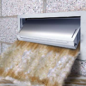
An unfinished flood-resistant enclosed area below the lowest floor (or an attached garage below the flood protection level) can be permitted if it is usable solely for vehicle parking, building access, or limited storage. This area must be properly vented to allow for equalization of hydrostatic forces and meet design and use criteria (see Floodplain Facts #8: Enclosed Areas Below the Flood Protection Level).
Anchoring
The building, any gas or liquid storage tanks, and any equipment servicing the building must be designed and anchored to prevent flotation, collapse, or lateral movement during the 100-year flood event. In addition to anchoring the building to its foundation, it is necessary to ensure that the foundation won’t move (due to hydrostatic forces, hydrodynamic forces, or undercutting by erosion or scour). In areas where flood velocities exceed five feet per second, additional anchoring measures may be required, such as reinforcing crawlspace walls, using deeper footings, using extra bolts to connect the sill to the foundation, or other measures
Flood Resistant Design, Materials, and Utilities
All parts of the building that are located below the flood protection level must be resistant to flood damage. This is generally accomplished by locating machinery, equipment, and other vulnerable components above the first floor. Those parts of the building located below the BFE (such as foundation elements, floor beams and joists, and utility equipment) must be made of flood-resistant materials and constructed using methods and practices that are resistant to flood damage. (Additional information and references are provided in Floodplain Facts #9: Flood Resistant Design.)
Additional Resources
- Elevated Residential Structures, FEMA 54 (1984), provides information about elevating residential buildings, including site analysis, architectural design examples, and construction guidelines.
- Ensuring that Structures Built on Fill In or Near Special Flood Hazard Areas are Reasonably Safe from Flooding, Technical Bulletin 10-01, FEMA FIA-TB-10 (2001), is a technical bulletin provides guidance on the construction of buildings on land elevated through the placement of fill.
- Above the Flood: Elevating Your Floodprone House, FEMA 347 (2000), describes alternative techniques that can be used to elevate existing floodprone houses and presents case studies of homes in south Florida that were elevated above the 100-year flood level following Hurricane Andrew.
- Flood-Resistant Design and Construction, American Society of Civil Engineers (ASCE) 24-05, purchase at www.asce.org, highlights available at FEMA. ASCE 24 is a referenced standard in the California Building Code. Buildings designed according to ASCE 24 are better able to resist flood loads and flood damage.
What is the Flood Protection Level?
If a “Base Flood Elevation” is indicated on the floodplain map issued by FEMA or is available from another source, then non-residential buildings must be protected from flood damage to a level two feet above this height. If no BFE is available, a registered civil engineer should establish the flood protection level.
The Base Flood Elevation (BFE) is the calculated water height for the flood that has a 1% probability of being equaled or exceeded in any given year (the 100-year flood).
Elevation of the Building
Elevation is the preferred method of protecting non-residential buildings from flood damage. In non-coastal floodplains, this requires location of the lowest floor at or above the flood protection level. A basement that is below grade on all sides is prohibited. Elevation can be accomplished by:
- Elevation on properly compacted fill;
- Elevation on piles, posts, piers, or columns; or
- Elevation on walls or a crawl space.

Elevation Certificate
To ensure that a building is properly elevated, the lowest floor is surveyed by a licensed land surveyor or registered civil engineer, and an Elevation Certificate is obtained and kept by the local permit office. This certificate is also used to rate flood insurance policies.
Elevation Certificate Update! 2019 EC Form is now available on FEMA's website.
Enclosed Areas Below the Lowest Floor
An unfinished, flood-resistant, enclosed area below the lowest floor can be permitted if it is usable solely for vehicle parking, building access, or limited storage. This area must be properly vented to allow for equalization of hydrostatic forces and meet design and use criteria (see Floodplain Facts #8: Enclosed Areas Below the Flood Protection Level).
New non-residential construction located in the regulated floodplain must be protected against flood damage from a 100-year flood event by elevation of the structure or dry floodproofing. In addition to new buildings, “new construction” also includes all improvements to existing post-FIRM structures (built after the community began regulating floodplain development). If a building is “substantially improved” or has been “substantially damaged” the entire structure must be brought into compliance with the current standards for new non-residential construction.
Dry Floodproofing
As an alternative to elevation, floodproofing of non-residential buildings is permitted. Dry floodproofing requires that the structure be watertight below the flood protection level, with walls substantially impermeable to the passage of water. All structural components located below the flood protection level must be capable of resisting hydrostatic and hydrodynamic loads and the effects of buoyancy. Utilities must be protected from flood damage. Most floodproofing is appropriate only where floodwaters are less than three feet deep, because walls and floors may collapse under higher water levels. Techniques that require human intervention are only appropriate if there is adequate warning time (12 hours is a recommended minimum) and someone will be present who is capable of implementing or installing the required measures.
Elevation Certificate
A registered professional engineer or architect must prepare the building plans and certify that the proposed dry floodproofing measures will meet the required criteria. Upon completion of the floodproofed portion of the structure, a licensed professional certifies the as-built floodproofed elevation.
Anchoring
The building, any gas or liquid storage tanks, and any equipment servicing the building must be designed and anchored to prevent flotation, collapse, or lateral movement during the 100-year flood event. In addition to anchoring the building to its foundation, it is necessary to ensure that the foundation won’t move (due to hydrostatic forces, hydrodynamic forces, or undercutting by erosion or scour). In areas where flood velocities exceed five feet per second, additional anchoring measures may be required, such as reinforcing crawlspace walls, using deeper footings, using extra bolts to connect the sill to the foundation, or installing rods to connect the cap to the sill.
Flood Resistant Design, Materials, and Utilities
Whether the structure is elevated or floodproofed, all parts of the building that are exposed to floodwaters must be resistant to flood damage. This involves the use of flood resistant materials and designs. (Additional information and references are provided in Floodplain Facts #9: Flood Resistant Design.)
Additional Resources
- Elevated Residential Structures, FEMA 54 (1984), provides information about elevating buildings, including site analysis, architectural design examples, and construction guidelines.
- Ensuring that Structures Built on Fill In or Near Special Flood Hazard Areas are Reasonably Safe from Flooding, Technical Bulletin 10-01, FEMA FIA-TB-10 (2001), is a technical bulletin providing guidance on the construction of buildings on land elevated through the placement of fill.
- Above the Flood: Elevating Your Floodprone House, FEMA 347 (2000), describes alternative techniques that can be used to elevate existing floodprone buildings and presents case studies of homes in south Florida that were elevated above the 100-year flood level following Hurricane Andrew.
- Non-Residential Floodproofing - Requirements and Certification, TB 3 (2020), provides guidance on the NFIP regulations concerning watertight construction and the required certification for floodproofed non-residential buildings.
- Below-Grade Parking Requirements for Buildings Located in Special Flood Hazard Areas, Technical Bulletin 6-93, FEMA FIA-TB-6 (1993), provides guidance on the NFIP regulations concerning the design of dry-floodproofed below-grade parking garages for non-residential buildings.
- Flood-Resistant Design and Construction, American Society of Civil Engineers (ASCE) 24-05, available for purchase at ASCE, with highlights available at FEMA. ASCE 24 is a referenced standard in the California Building Code. It includes standards for resisting flood loads and flood damage and for dry floodproofing of nonresidential buildings.
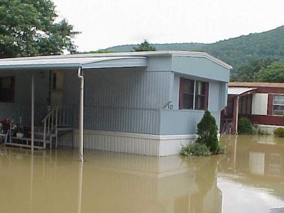
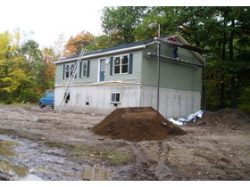
Manufactured Homes
Manufactured homes must meet the same standards as any other residential building for elevation of the first floor, use of flood damage-resistant materials below the flood protection level, and elevation or protection of utilities. The best way to meet this requirement is to elevate the bottom of the manufactured home chassis to the flood protection elevation (see Floodplain Facts #4: Residential Structures in the Floodplain).
Manufactured home means a structure, transportable in one or more sections that is built on a permanent chassis and designed to be used with or without a permanent foundation when connected to the required utilities. This includes older mobile homes that pre-date current manufactured home standards.
Manufactured homes must be elevated on a permanent foundation and be securely anchored to an adequately anchored foundation system to resist flotation, collapse, and lateral movement.
A “permanent foundation” means more than a stack of concrete blocks. It should include a below-grade footing that is capable of resisting overturning, deep enough to account for frost depth and expected scour, and sized appropriately for the site’s soil bearing capacity. “Adequately anchored” means a system of ties, anchors, and anchoring equipment that will withstand flood and wind forces and will work in saturated soil conditions. Usually this means over-the-top or frame tie-downs in addition to standard connections to the foundation.
If a solid perimeter foundation wall (or rigid skirting that is attached to the frame or foundation) encloses space below a manufactured home, openings are required to relieve hydrostatic loads and minimize the potential for damage to the home and its supporting foundation system (see Floodplain Facts #8: Enclosed Areas Below the Flood Protection Level). Flexible skirting or rigid skirting that is not attached to the frame or foundation does not trigger the requirement for flood vent openings, provided that the skirting does not provide structural support and will collapse under water loads without causing structural damage to the elevated home or the foundation.
Replacement of an existing manufactured home
with a new structure constitutes a substantial improvement, which means that the entire structure must comply with current elevation, construction, and anchoring requirements.
Recreational Vehicles and Trailers
A recreational vehicle or trailer located in the regulated floodplain must:
- Meet the elevation and anchoring requirements for manufactured homes; OR
- Be on the site for fewer than 180 consecutive days; OR
- Be fully licensed and ready for highway use (i.e. on its wheels or jacking system, attached to the site only by quick disconnect type utilities, and with no permanently attached additions).
Recreational vehicle or trailer means a vehicle that is: (1) built on a single chassis; (2) 400 square feet or less when measured at the largest horizontal projections; (3) designed to be self-propelled or permanently towable by a light duty truck; and (4) not designed primarily for use as a permanent dwelling but as temporary living quarters for recreational, camping, travel, or seasonal use.
Recreational Vehicle and Trailer Parks
If a campground or recreational vehicle park is located in the floodplain, it should have an emergency plan that specifies how flood warnings will be received and how vehicles, trailers, and occupants will be safely evacuated in the event of a flood. If there will not be sufficient warning time to ensure that recreational vehicles and trailers will be removed prior to flooding, they should either be located outside of the floodplain or installed in a manner that meets the elevation and anchoring requirements for manufactured homes.
Additional Resources
- Manufactured Home Installation in Flood Hazard Areas, FEMA 85 (1985), provides technical guidance on installation methods designed to make manufactured homes more resistant to flood and wind forces. It is currently being revised.

“Accessory structure” means a structure the use of which is incidental to that of the main building and which is located on the same lot. This does not include gas and liquid storage tanks, which are considered structures for floodplain management purposes.
Structures That Do Not Have At Least Two Rigid Walls
Some accessory structures, such as carports, gazebos, and picnic pavilions, do not qualify as “buildings” because they do not have at least two rigid walls. This type of non-building development does not need to be elevated or floodproofed, but should be anchored and constructed using flood damage-resistant materials so that it is “reasonably safe” from flood damage.
Attached Garages
A garage attached to a residential structure with the floor slab located below the flood protection level can be regulated as a non-elevated “enclosed area” if it is used only for parking of vehicles, building access, and storage and meets the requirements for flood openings and flood damage-resistant materials (see Floodplain Facts #8: Enclosed Areas Below the Flood Protection Level).
The flood protection level is the height to which development should be elevated or otherwise protected from flood damage. If a ‘base flood elevation’ (100-year flood height) is indicated in the Flood Insurance Study (or available from another reliable source), flood protection should be provided to a level at least two feet above the base flood elevation. If no base flood elevation is available, flood protection should be to a level at least three feet above the highest adjacent grade.
Agricultural Structures
Some agricultural structures, such as farm storage structures, and some general purpose barns can be protected from flood damage using wet floodproofing techniques. However, this is only permitted if a variance is obtained from the County (see Floodplain Facts #13: Floodplain Variances). Use must be limited to agricultural purposes and construction must be consistent with the anchoring, flood resistance, and flood vent requirements (see Wet Floodproofing Standards below).
“Wet floodproofing” includes permanent or contingent measures applied to a structure and/or its contents that prevent or provide resistance to damage from flooding by allowing flood waters to enter the structure.
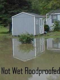
Other Accessory Structures
In some cases, low-cost accessory buildings may be wet-floodproofed instead of meeting the requirements for elevation or dry floodproofing of buildings. These structures could include small detached garages, storage sheds, and pole barns. Criteria for determining whether an accessory structure can be sufficiently protected using wet-floodproofing techniques include:
- The building must be used only for parking of vehicles or storage of tools, materials, and equipment;
- The structure shall not be designed or used for human habitation, either currently or in the future;
- The accessory structure represents a minimal investment of less than 10% of the value of the property;
- The structure will have low flood damage potential with respect to both the structure and its contents; and
- Permanently affixed sanitary facilities, utility equipment, and appliances (such as furnaces, heaters, washers, dryers, etc.) are prohibited.
Wet Floodproofing Standards
All floodplain development must be consistent with the need to minimize damage. For wet floodproofed accessory structures, the standards for achieving this are:
- The building must be adequately anchored to resist flotation, collapse, and lateral movement;
- The portion of the building that is located below the flood protection level must be constructed of flood-resistant materials;
- The building must have the required openings to allow for the automatic entry and exit of flood waters; and
- Any electrical or mechanical equipment (such as electric boxes, switches, and outlets) must be elevated or floodproofed to or above the flood protection level.
(Additional information and references are available in Floodplain Facts #8: Enclosed Areas Below the Flood Protection Level and Floodplain Facts #9: Flood Resistant Design.)
Non-Conversion Agreement
Accessory structures with the floor located below the flood protection level are designed to be flooded and should not be converted to uses that are incompatible with the flood hazard. Conversion to finished living space, blockage of flood vents, or installation of unprotected equipment (appliances, heating/cooling equipment, plumbing fixtures, etc.) may violate the conditions of the floodplain development permit or the floodplain variance. The municipality may require the owner to sign a non-conversion agreement to document their understanding of the limitations on construction and use of the enclosed area.
Flood Insurance Considerations: A detached garage can be included under a residential flood insurance policy if: (1) it is used only for parking of vehicles and limited storage and (2) the value does not exceed 10% of the value of the primary structure. However, a garage that does not meet these conditions or another type of accessory building would require a separate policy for flood insurance coverage. The insurance rating (i.e. cost) for such a policy can be quite high for wet floodproofed structures because it would be based on the elevation of the lowest floor (or the dry floodproofing level) relative to the Base Flood Elevation (100-year flood elevation).
Additional Resources
- Wet Floodproofing Requirements , Technical Bulletin 7, FEMA FIA-TB-7 (2020), includes planning, safety, and engineering considerations for wet floodproofing.
Enclosures
When solid walls fully enclose an area that is subject to flooding, those walls and the enclosure should be designed to resist damage from a flood. Of particular concern is the potential for solid walls to collapse from hydrostatic pressure if floodwaters get too deep outside of the building. Standards applicable to flood-prone enclosures apply to:
- Crawl spaces and other enclosed areas below the lowest floor of floodplain buildings;
- Structurally attached garages with the floor slab located below the flood protection level;
- Accessory structures with the floor below the flood protection level; and
- Existing structures for which increased flood resistance is desired.
Allowed Uses
For new construction or substantially improved structures (which must comply with floodplain development standards), enclosed areas below the flood protection level can only be used for parking of vehicles, building access, or storage. The interior portion shall not be partitioned, temperature-controlled, or finished into separate rooms. Because these areas are intended to flood, storage should be limited to items that have a low damage potential or can be easily moved to the elevated portion of the building if there is a flood.
Required Openings in Enclosure Walls
The walls of any enclosed area below the flood protection level must be designed to automatically equalize hydrostatic forces that result from the pressure of floodwaters against the structure. This is accomplished by installing openings, or flood vents, through which water can enter and exit the enclosure to maintain equal levels on both sides of the wall.
A “flood vent” is a permanent opening in a wall that allows the free passage of water automatically in both directions without human intervention.
Designs for flood vent openings must either (1) be certified by a licensed design professional or (2) meet or exceed the following requirements for non-engineered openings:
- The openings shall be installed on at least two walls of each enclosed area;
- The bottom of the openings must be no higher than one foot above the adjacent finished grade;
- The openings shall have a total net area of not less than one square inch for every square foot of enclosed area subject to flooding; and
- Openings shall be at least three inches in diameter.
Enclosed areas that are sub-grade on all sides are considered basements and are not permitted in floodplain structures.
Openings may be equipped with screens, louvers, valves, or other coverings or devices, provided that they permit the automatic entry and exit of floodwaters. However, the area occupied by any obstructions must be subtracted when determining the “net area” of the opening. Insect screens do not affect the net open area. The requirement that the opening be at least three inches in diameter applies to the hole in the wall, excluding any device that may be inserted.
If the floor of the enclosure is below the Base Flood Elevation (100-year flood height indicated in the Flood Insurance Study and on the flood hazard map), then only those portions of openings that are below the Base Flood Elevation can be counted toward the required net open area.

Crawl space ventilation vents are designed to facilitate the flow of air and generally do not meet the requirements for flood vents. However, in some circumstances it is possible to design permanent openings that satisfy the required criteria for flood openings as well as ventilation.
Windows, doors, and garage doors are not considered openings for flood venting purposes. However, openings that meet the flood vent standards can be installed in doors and windows.
Flood vents not meeting the above criteria are allowed only if a registered professional engineer or architect certifies that the design meets the requirement to automatically equalize hydrostatic forces on the exterior walls by allowing for the entry and exit of floodwaters. This certification should be attached to the Elevation Certificate.

If flood vent openings do not comply with National Flood Insurance Program requirements, the floor of the crawlspace, attached garage, or other enclosure becomes the “lowest floor” of the structure. This may result in significantly higher flood insurance premiums, which would be based on the elevation of the enclosure floor relative to the 100-year flood elevation.
Several manufacturers have developed products that meet the flood venting requirements. Some of these products are certified to enable equalization of water pressure with smaller openings.
Flood Resistant Materials
Since floodwaters are intended to enter the enclosure, it must be built of flood-resistant materials. This precludes the use of finishings such as carpeting, paneling, insulation (both cellulose and fiberglass) and gypsum wallboard (drywall or sheet rock). Any utilities, ducts, or electrical service must be located or designed to prevent damage from flooding. (Additional information and references concerning flood damage-resistant materials and methods is provided in Floodplain Facts #9: Flood Resistant Design.)
High Velocity Considerations
In riverine flood hazard areas where flow velocities are expected to exceed five feet per second, the recommended flood vent openings may not be sufficient to protect solid perimeter foundation walls from hydrodynamic loads and the potential for debris impact and scour. In these areas, it is recommended that buildings be elevated on fill or on open foundations, such as posts, columns, or pilings. All of the requirements for enclosed areas below such structures would apply.
Non-Conversion Agreement
Enclosed areas below the flood protection level are designed to be flooded and should not be converted to uses that are incompatible with the flood hazard. Conversion to finished living space, blockage of flood vents, or installation of unprotected equipment (appliances, heating/cooling equipment, plumbing fixtures, etc.) violates the conditions of the floodplain development permit. The municipality may require the owner to sign a non-conversion agreement to document their understanding of the limitations on construction and use of the enclosed area.
Additional Resources
Openings in Foundation Walls and Walls of Enclosures, Technical Bulletin 1, FEMA FIA-TB-1 (2020), This technical bulletin provides guidance for non-engineered and engineered flood openings.
What Does “Flood Resistant” Mean?
Floodplain areas can be subjected to hydrostatic (standing water) and hydrodynamic (flowing water) pressures during floods. These pressures can result in displaced foundation walls, collapsed structures, floating fuel tanks, scouring, and other damage. Flood resistance thus requires that structural and non-structural components be durable, resistant to flood forces (including buoyancy), and resistant to deterioration caused by inundation with floodwater. Options that require emergency operation (such as shutting off electricity or removing vulnerable components) should be avoided if possible, particularly in areas subject to flash flooding. “Flood resistant” is not “dry floodproofing” of non-residential structures.
Flood Damage-Resistant Building Materials
It is important that all parts of a building or other project that are susceptible to flooding (including fasteners and connectors) be made of materials that are resistant to flood damage. “Flood-resistant materials” include any building product capable of withstanding direct and prolonged contact with floodwaters without sustaining significant damage. “Prolonged contact” means at least 72 hours, and “significant damage” is any damage requiring more than cleaning or low-cost cosmetic repair (such as painting). The need to replace flood damaged drywall or other material is considered “significant damage” and is thus not acceptable. Components that are not inundated should be resistant to excessive humidity.
Flood damage-resistant materials include:
- Glazed brick, concrete, concrete block, glass block or stone (with waterproof mortar or grout);
- Steel trusses, headers, beams, panels, or hardware;
- Naturally decay resistant lumber, recycled plastic lumber, or marine grade plywood;
- Clay, concrete, rubber, or steel tiles (with chemical-set or waterproof adhesives);
- Cement board;
- Metal doors, cabinets, and window frames;
- Mastic, silicone, or polyurethane formed-in-place flooring;
- Sprayed polyurethane foam or closed-cell plastic foam insulation;
- Water-resistant glue; and
- Polyester epoxy paint (mildew-resistant paint contains toxic ingredients and should not be used indoors).
Anchoring

Foundations, equipment, accessory structures, and other components located below the flood protection level must be firmly anchored to resist flotation, collapse, and lateral movement.
Mechanical, Plumbing, and Electrical Systems
Location above the flood protection level is generally the best way to protect service equipment, such as heating, ventilating, air conditioning, plumbing appliances, plumbing fixtures, duct systems, and electrical equipment (service panels, meters, switches, and outlets). If these components are at a lower level, they must be designed to prevent damage from flooding. This may involve waterproof enclosures, barriers, protective coatings, or other techniques to protect vulnerable components. The County may require certification from a licensed professional that the standards for resistance to flood damage are met.
Backflow and Automatic Shut-Off Valves
Flooding can cause sewage from sanitary sewer lines to back up into buildings through drain pipes, causing both damage and health hazards. Backflow valves are designed to temporarily block pipes and prevent flow into the building and should be installed on any pipes that leave the building or are connected to equipment located below the flood protection level. In addition to sanitary sewer and septic connections, this may include water lines, washing machine drain lines, laundry sinks, downspouts, and sump pumps. Fuel supply lines must be equipped with float operated automatic shut-off valves.
Storage Tanks
Unanchored fuel tanks can be easily moved by flood waters, posing a serious threat of contamination and other damage. Even a buried tank can be pushed to the surface by buoyant effects. A tank can be anchored by attaching it to a concrete slab that is heavy enough to resist the force of flood waters or by running straps over it and attaching them to ground anchors. Tanks and other containers should have watertight fill caps, vents that extend above the flood protection level, and accurate labeling of contents (so that emergency personnel know what it contains if the tank breaks loose and floats away).
Certification of Flood Resistant Design
If the local building official is unable to confirm that a proposed design is resistant to flood damage, the County may require certification from a licensed professional engineer or architect prior to issuing a floodplain development permit. Situations in which certification may be necessary include: wet floodproofed utilities or equipment, anchoring, septic systems, gas well equipment, or flood-resistant materials not listed in FEMA’s Technical Bulletin 2.
Additional Resources
- Wet Floodproofing Requirements , Technical Bulletin 7, FEMA FIA-TB-7 (2020), includes planning, safety, and engineering considerations for wet floodproofing.
- Flood Damage-Resistant Materials Requirements for Buildings Located in Special Flood Hazard Areas, Technical Bulletin 2, FEMA FIA-TB-2 (2008), includes lists of acceptable materials for flood-resistant construction.
- Protecting Building Utilities from Flood Damage: Principles and Practices for the Design and Construction of Flood Resistant Building Utility Systems, FEMA 348 (1998). This publication provides technical guidance for the design and construction of flood-resistant utility systems, including HVAC systems, fuel systems, electrical systems, sewage management systems, and potable water systems.
- Elevator Installation for Buildings Located in Special Flood Hazard Areas, Technical Bulletin 4-93, FEMA FIA-TB-4 (1993), Provides guidance concerning the installation of elevators below the Base Flood Elevation.
- Flood-Resistant Design and Construction, American Society of Civil Engineers (ASCE) 24-05, purchase at ASCE, highlights available at FEMA. ASCE 24 is a referenced standard in the California Building Code. Buildings designed according to ASCE 24 are better able to resist flood loads and flood damage.
Limited Flood Hazard Data
Because detailed floodplain studies are expensive, the floodplains in many rural areas were estimated using approximate techniques. The resulting flood hazard maps delineate the boundaries for the “Special Flood Hazard Area” (100-year floodplain) within which development must comply with floodplain development standards. However, no information is provided regarding the Base Flood Elevation (BFE; anticipated depth of flooding). And no Regulatory Floodway (area reserved to discharge flood flows) is delineated. In the absence of detailed flood hazard information, it is still necessary to ensure that development is reasonably safe from flood damage.
Use of Other Flood Data
When development is proposed in an Approximate A Zone, the County must “obtain, review and reasonably utilize any base flood elevation and floodway data available from a Federal, State, or other source...” [44 CFR 60.3 (b) (4)]. Information from other sources should be used as the basis for regulating floodplain development if it: (1) reasonably reflects flooding conditions expected during the base flood (which has a 1% probability of being equaled or exceeded in any given year, i.e. the 100-year flood), (2) is not known to be technically incorrect, and (3) represents the best available data. If authoritative BFE and floodway data are not available, historical flood heights or other information can provide guidance.
Approximate A Zones are those areas where floodplain boundaries have been established using approximate techniques without conducting detailed hydrologic and hydraulic studies. These approximate 100-year flood zones are shown on flood hazard maps as “unnumbered A zones” (the letter “A” with no letter or number after it).
Possible sources of flood data include:
- Flood Hazard Maps: Provisional or advisory flood hazard maps can be used for floodplain management prior to being finalized or adopted (unless the technical validity is being questioned). Near a municipal boundary, flood elevations developed for the neighboring community may be applicable.
- Highway Departments: If the area is near a bridge or other highway structure, a flood study may have been done to size the structure.
- Other Agencies: Flood studies, reports, or other data may be available from agencies that have worked with the stream or watershed, such as U.S. Army Corps of Engineers, U.S. Geological Survey, USDA Natural Resources Conservation Service, or the Santa Clara Valley Water District.
- Applicant: The applicant must provide Base Flood Elevations (developed using a “detailed method”) for any proposed development that is greater than either 50 lots or 5 acres if one or more structures or building sites are in an Approximate A Zone. For smaller projects, a BFE may be requested.
- County: The County may develop Base Flood Elevation and/or Floodway data for regulating development in Approximate A Zones. This is advisable if multiple applications are anticipated. “Simplified methods” for determining BFEs can be sufficient for floodplain management purposes and are less costly than the “detailed methods” required for flood hazard map revisions and insurance ratings.
- Historical Sources: The County should also consult with neighbors, staff, or others who may have knowledge of historical flood heights at or near the proposed development.
Determining the Base Flood Elevation (BFE)
The “Base Flood Elevation” is the calculated water height that has a 1% probability of being equaled or exceeded in any given year (the 100-year flood). The Federal Emergency Management Agency (FEMA) provides guidance for developing BFEs using “detailed methods” (similar to those used for flood hazard map development) and “simplified methods” (that can be used to mange development in isolated areas). When a developer is required to provide BFEs for a large project, a “detailed method” is required.
Flood Protection Level
In Approximate A Zones, the level to which development should be protected from flood damage (by elevation or other means appropriate to the type of development) depends on the available information:
- Two or more feet above BFE – required if BFE is available from a reliable source or has been developed;
- Two or more feet above historic flood levels – recommended if prior flood depths exceeded one foot and the lot is less than 5 acres in area;
- The County can require the developer to determine the BFE (since the project must be consistent with the need to minimize flood damage.) for lots larger than 5 acres in area.
Proposed Development Shall Not Result in Physical Damage to Any Other Property
Although floodway delineations are typically not available in Approximate A Zones, the concept of reserving room for flood flows still applies. A floodplain permit cannot be issued for development that would result in physical damage to any other property. If the potential for damage exists (due to increased flood heights, stream bank erosion, increased flood velocities, etc.), the County can require a technical analysis by a registered civil engineer to facilitate this determination. This analysis may be warranted for any project (bridge, berm, building, fill, etc.) that encroaches on the channel or obstructs flood flows.
Locate Development Outside of the Floodplain
Because Approximate A Zones are usually located in rural areas or along small streams, it is often feasible to locate development outside of the mapped floodplain. This is the preferred option because it protects development from flood hazards, reduces the risk of damage from stream bank erosion, preserves natural floodplain functions, and protects occupants and users who might otherwise require evacuation during a flood. It may also save on the cost of a flood study (for larger developments) and the subsequent cost of flood insurance for building owners.
Flood Insurance Consideration: If the elevation of a building in an Approximate A Zone is documented on an Elevation Certificate (generally required by the community to confirm compliance with development standards), the cost of flood insurance is rated in one of the following ways:
1. If there is no BFE, the building is rated based on its height above the highest adjacent grade.
2. If the community provides a locally developed BFE that was determined using detailed methods, the building is rated based on its height relative to that BFE.
The insurance costs will generally be lower for a building with the first floor two feet above the BFE (minimum standard if the BFE is available) than for a building with the first floor three feet above grade (without a BFE). It may be more cost effective in the long run to hire an engineer to develop a BFE, than to insure a building constructed without that information.
Additional Resources
- Managing Floodplain Development in Approximate Zone A Areas: A Guide for Obtaining and Developing Base (100-Year) Flood Elevations, FEMA 265 (1995) provides engineering guidelines for determining Base Flood Elevations using simplified and detailed methods.
- QUICK-2 Version 2.0, FEMA, software and tutorial for computing flood elevations using detailed methods.
Anywhere it rains, it can flood!
About one-third of all flood insurance claims are for properties outside of the mapped Special Flood Hazard Areas.
For floodplain mapping purposes, shallow flooding is defined as flooding with an average depth of one to three feet in areas where a clearly defined channel does not exist. This can occur for a variety of natural or human-caused reasons. Some areas of shallow flooding are identified on flood hazard maps – many are not.
Special Flood Hazard Areas (100-year Floodplains)
Flood hazard maps may show areas labeled as “Zone AO” or “Zone AH” that are expected to experience shallow flooding during a 100-year flood event. These are “Special Flood Hazard Areas” and are subject to floodplain development regulations. If the anticipated depth of the 100-year flood has been determined, it may be indicated as the depth in feet above the ground (in Zone AO) or as the Base Flood Elevation above sea level (in Zone AH). When this is specified, development should be protected to a level two feet above the specified flood depth or elevation. If no flood depth is indicated on the map (or available from another source) then development should be protected to a level 4 feet above the highest adjacent grade.
Other Flood-Prone Areas
Many areas prone to flooding are not identified on flood hazard maps. Shallow flooding can be a problem in developed areas where drainage systems (swales, ditches, storm sewers, stormwater ponds, etc.) are overloaded by large storms. It can also occur naturally on alluvial fans, in areas with sheet flow, in depressions where water ponds, and in shallow drainageways that are normally dry. In addition, debris accumulation, ice jams, and extreme events can contribute to flooding beyond the mapped floodplain boundaries. When flood-prone areas are not identified on flood hazard maps and designated as Special Flood Hazard Areas, development requirements may not be sufficient to protect against flood damage. The following information can be used as guidance for protecting development in these areas.
What Is the Flood Hazard?
Just because a site is not in a mapped floodplain doesn’t mean that it is safe from flooding. It only means that the site was not recognized as a “high flood hazard area” (with water depths greater than one foot) when the map was developed. Moderate to low flood hazard areas can and do flood. And it only takes a few inches of water inside a house to cause thousands of dollars in damage. Resources that are helpful for identifying and investigating flood hazards include:
- Flood Hazard Maps. Flood hazards should be taken into account for any development in or near a 100-year or 500-year floodplain. The mapped floodplain boundaries are based on model results and may change with time due to changing conditions and/or improved mapping techniques. The flood potential may change due to development or other land use changes in the watershed. It is wise to prepare for mapped flood hazards, the possibility of increased hazards, and the potential for larger flood events.
- Soil Surveys. Soil survey maps can be used to evaluate the potential for flooding or shallow groundwater conditions. Soil descriptions and tables published with these maps indicate the limitations associated with different soil types. Soil survey information is available online at The USDA.
- History. Neighbors, municipal officials, and others may be able to tell you if an area has experienced water problems in the past. But keep in mind that no flooding in the last 20 years doesn’t mean that there will be none in the next 20 years.
- Rainy Day. Look at the site in the rain and pay attention to where the water goes; think about where it would go if there was a lot more water. Look for low areas and intermittent drainage ways. Is there a dam, dike, earthen berm or other structure that could impact the area if it overtopped or failed? Is there a bridge, culvert, or storm drain that could plug with debris? How close is the nearest stream? Remember that “little creeks” can cause “big floods.”
If maps, soils, historic drainage patterns, or other clues indicate a potential for flooding, then protect your investment by incorporating the flood risk into the site layout, project design, and materials used.
Location
Locate development on high ground in an area that will not be subject to drainage or erosion problems.
- Resist the temptation to fill in a boggy area or shallow swale to construct a house. Water often retains its historic flow pattern, which can damage the foundation or basement. An additional concern is the impact that diverted flow may have on surrounding areas, which may develop unanticipated drainage problems.
- Leave a vegetated buffer between developed areas and streams or wetlands. Woody vegetation helps to maintain the stability of stream systems and also reduces the risk of flooding, erosion, or sediment damage. Some streams can move fifty feet or more during a single flood event.
Build High (to Stay Dry)
Since water flows downhill, it’s a good idea to elevate buildings and other vulnerable items in any flood-prone location. Within Special Flood Hazard Areas (regulated floodplains), basements are prohibited and buildings must be elevated or floodproofed to (or above) the designated flood protection level. The same strategy can be used in other areas. If there is a risk of shallow flooding, avoid wet basement problems and elevate the first floor at least three feet above grade. If the depth of historic flooding is known, try to elevate or protect your project to a level two feet above the historic high water mark.
Drain Water Away from Buildings
Within Flood Zones AH and AO, adequate drainage paths are required to guide flood waters around and away from proposed structures on slopes. In addition, the California Building Code requires grading of building sites in a manner that diverts surface drainage away from foundations. However, you cannot deflect flow onto adjacent properties.
Flood Resistant Design and Materials
The foundation and lower portions of a building should be designed to withstand the effects of any anticipated flooding by utilizing flood damage-resistant materials, adequate anchoring, and elevation of sensitive components. In addition, it is important that any basement or other enclosed area be designed to either withstand the hydrostatic pressure of water or to equalize pressure by allowing water to enter and exit the enclosure. (See also Floodplain Facts #8: Enclosed Areas Below the Flood Protection Level and Floodplain Facts #9: Flood Resistant Design.)
Flood Insurance
Since homeowners’ insurance policies generally do not cover flooding, it is advisable to purchase flood insurance coverage for both buildings and contents in flood-prone areas. In mapped floodplains, most mortgage lenders require flood insurance coverage for the building. In other areas, insurance costs are lower and may provide valuable protection against financial losses from flooding.
Why Is the Floodway Different than Other Floodplain Areas?
A basic principle of floodplain management is that development must not increase the flood hazard on other properties. “Floodways” are areas where fill or other development is likely to divert flow and contribute to increased water depths during a flood. Floodways may also be subject to high velocities, which can cause severe damage to structures and high risks for occupants and emergency responders. Ideally, floodways should be undeveloped areas that can accommodate flood flows with minimal risk. Any new development in the floodway generally requires an engineering analysis of the impact on flood hazards.
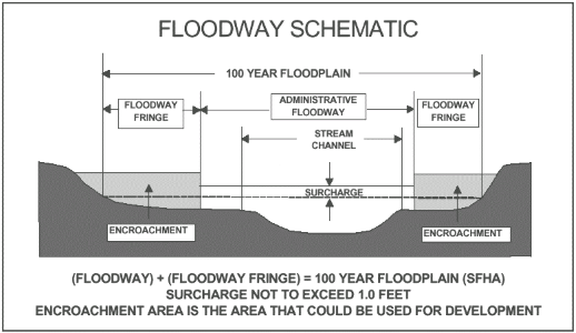
The floodway is the channel of a river or stream and the overbank areas that must remain open to carry the deeper, faster moving water during a flood. If the remainder of the floodplain, called the floodplain fringe, is completely obstructed, the 100-year flood elevation would not increase more than one foot. The regulatory floodway may be shown on the Flood Insurance Rate Map or on a separate Flood Boundary and Floodway Map. Because floodway boundaries are delineated using computer modeling, they often do not correspond to any features visible at the site.
What Is Meant by Encroachment?
An “encroachment” is any floodplain development that could obstruct flood flows, such as fill, a bridge, or a building. A driveway, road, or parking lot at grade (without any filling) would not cause an obstruction. Development of lakeshore floodplains, where there is no flow, is not considered an encroachment.
How Are Floodplain Encroachments Regulated?
The development standards for a floodplain encroachment depend on both the project location and the amount of information provided on flood hazard maps:
- Floodplain fringe: The modeling used to establish floodway boundaries indicated that any encroachment or obstruction in the fringe area (outside the floodway) would not result in a “significant” increase in flood levels (i.e. no more than one foot), so no encroachment analysis is required.
- Floodway: No new development is permitted within the regulatory floodway unless a licensed professional engineer demonstrates that the proposed encroachment shall not result in any rise in the 100-year flood elevation. This no-rise requirement is in addition to all other floodplain development standards applicable to the proposed project.. A variance is a request to vary from the rules, not to ignore them. Any variance should allow only minimum deviation from the local requirements. The approved project should provide as much flood protection as is possible.. Because the community should not be exposed to higher flood risks, federal standards prohibit variances from the requirements concerning floodway encroachments.
- Riverine floodplain with base flood elevations, but no floodway: When the flood hazard map designates base flood elevations (100-year flood heights) but no floodway is delineated, the applicant must demonstrate that the cumulative effect of the proposed development, when combined with all other existing and anticipated floodplain development, would not increase the water surface elevation of the 100-year flood more than one foot at any location.
- Approximate A Zones: When floodplain boundaries were established using approximate techniques (which produce neither floodways nor base flood elevations), the municipality may require an analysis to demonstrate that the project would not result in physical damage to any other property.
Are There Exceptions to the Encroachment Requirements?
Federal standards do not allow communities to issue variances for development within the floodway that would result in increased flood levels. However, there are some situations (such as dams, bridges, or roads) in which a project in the floodway may be justifiable even though it would cause a rise in the flood elevation. This necessitates that the flood hazard map be changed to reflect the new hazard. The applicant must apply to the Federal Emergency Management Agency (FEMA) for (1) a conditional map revision before the development occurs and (2) a final letter of map revision after the development has been completed.
No-Rise Certification for Floodway Encroachments
Any proposed encroachment in the floodway requires a technical evaluation by a licensed professional engineer to demonstrate that the project will not affect flood heights. The results of this analysis must be maintained in the municipality’s permit file. This can be in the form of a No-Rise Certification supported by technical data and signed by a registered professional engineer. The supporting technical data should be based on the standard step-backwater computer model used to develop the floodway shown on the flood hazard map. Hydraulic modeling of the pre-project and post-project conditions should demonstrate that the change in the 100-year flood height is 0.00 feet.
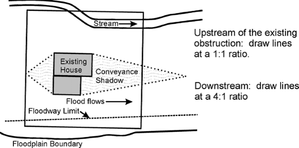
A detailed surface water profile analysis may not be necessary for a small project located completely within the “conveyance shadow” of an existing obstruction (because flood water is already flowing around the larger obstruction). The limits of this conveyance shadow can be determined as illustrated. However, an engineer must still certify that the floodway encroachment would not cause any rise in the flood elevation.
Additional Resources
- California Quick Guide, prepared by the California Department of Water Resources, Floodplain Management Branch provides guidance on meeting the “no-rise” and “no adverse effect” criteria using hydraulic modeling techniques.
- Procedures for Compliance with Floodway Regulations, Floodplain Management Information Series Special Report; prepared by U.S. Army Corps of Engineers, Federal Emergency Management Agency, and Pennsylvania Department of Community Affairs (1990) describes the analyses needed to document floodway impacts and procedures for requesting floodway revisions.
Local Floodplain Development Permit
Responsibility for issuing or denying Floodplain Development Permits lies with the Local Floodplain Administrator (usually the Code Enforcement Officer). If a proposed project does not comply with the County’s floodplain development standards, the Local Floodplain Administrator should deny the permit and provide a written summary of project deficiencies. The applicant may then revise and resubmit the application or request a hearing from the designated appeals board (usually the Zoning Board of Appeals).
Appeals
If the applicant alleges an error in the decision or determination made by the Local Floodplain Administrator, the appeal is heard and decided by the designated appeals board. If the applicant requests a variance from local floodplain development requirements, the variance request must be supported by a written justification. The request for variance should never be an after-the-fact request for a non-compliant project.
A variance is a grant of relief from the terms of a floodplain management regulation. This generally involves allowing development that is contrary to good floodplain management practices. Because the result can be an increased risk to life and property, the granting of floodplain variances should be rare.
Local Variance Procedure
The appeals board considers a variance request at one or more public meetings at which they seek (1) testimony from the Local Floodplain Administrator about how the proposed activity fails to meet local floodplain development standards and (2) testimony from the applicant as to why it is infeasible or impossible to make the proposed development conform. Complete records should be kept of all deliberations and actions of the board. (Use of a Floodplain Variance Findings & Decision form is recommended.)
Although an appeals board has the authority to decide whether or not a variance is granted, the Federal Emergency Management Agency (FEMA) may review the community’s findings. If that review indicates a pattern inconsistent with the objectives of sound floodplain management, the community can be subjected to probation or suspension from the National Flood Insurance Program.
State Variance Procedure
Because floodplain management requirements are specified in the California Building Code, it may be necessary to obtain a Variance to the Uniform Fire Prevention and Building Code from the State of California. This is in addition to a local variance from the County.
Considerations and Conditions
The County’s Flood Damage Prevention regulations specify factors that must be considered and conditions that must be met prior to granting a floodplain variance. Both the applicant and the appeals board should refer to these regulations to ensure that each issue is addressed in the applicant’s written justification and carefully considered during the board’s deliberations. Key issues are discussed below.
Good and Sufficient Cause
Because floodplain management regulations do not anticipate every imaginable situation, the variance process allows a developer to seek permission to vary from the letter of the rules because of a special situation. However, the variance must pertain to the land itself – not to the structure, its inhabitants, or the property owner. A variance should not be granted for a problem that can be resolved through other means, even if the alternative is more expensive, more complicated, requires that the parcel be put to a different use, or requires the applicant to build elsewhere.
Exceptional Hardship
Federal regulations state that a community can only issue a variance upon “a determination that failure to grant the variance would result in exceptional hardship to the applicant.” Additional guidance states: “The applicant has the burden of proving unnecessary hardship.” Reasons for granting the variance must be substantial; the proof must be compelling. The claimed hardship must be exceptional, unusual and peculiar to the property involved. Financial hardship, inconvenience, aesthetic considerations, physical handicaps, personal preferences or the disapproval of one’s neighbors do not qualify as exceptional hardships. (National Flood Insurance Program (NFIP) Floodplain Management Requirements, FEMA 480 (2005), page 7-46)
Minimum Variation Necessary
The variance must be the minimum necessary, considering the flood hazard, to afford relief. A variance is a request to vary from the rules, not to ignore them. Any variance should allow only minimum deviation from the local requirements. The approved project should provide as much flood protection as is possible.
Regulatory Floodway
Variances shall not be issued within any regulatory floodway if any increase in flood levels during the base flood discharge would result. Because the community should not be exposed to higher flood risks, federal standards prohibit variances from the requirements concerning floodway encroachments.
When Might a Variance Be Warranted?
Special circumstances may justify granting a variance:
- Deviation from Higher Standards: When the county’s floodplain management standards exceed the minimum federal requirements, some situations may warrant deviation from those higher standards.
- Small Lot: Although variances are strongly discouraged, the technical justification required for a building that fails to meet elevation requirements is lower if it is erected on a lot of one-half acre or less and surrounded by lots with existing structures constructed below the base flood elevation.
- Wet Floodproofing: Variances that allow protection from flood damage using wet floodproofing techniques may be issued for structures that are: functionally dependent on close proximity to water (such as boat houses), historic buildings (if the historic character is preserved), accessory structures, and certain agricultural structures. The variance may be contingent on limited use of the structure (for storage, parking, or agricultural purposes). In all cases, the variance must be the minimum necessary.
Impact of Increased Risk on Flood Insurance Rates
A variance is for floodplain management purposes only. It does not alter flood insurance purchase requirements or the mechanism for determining insurance costs. The increased risk for a non-compliant structure will be reflected in higher annual flood insurance premiums, which can be as high as $25 for $100 of insurance coverage. This may create severe financial consequences for the property owner who applied for the variance and for any future owners. Although a variance may save money in the short term, over the long run the owner may pay much more in insurance premiums or, if uninsured, in flood losses. If a variance is issued for a building with the lowest floor below the base flood elevation, the County must notify the applicant of the potentially high flood insurance premiums and the increased risks to life and property.
Additional Resources
- Santa Clara County Floodplain Ordinance
- Appeals, Special Uses and Variances, in Unit 7: Ordinance Administration of FEMA 480: National Flood Insurance Program (NFIP) Floodplain Management Requirements: A Study Guide and Desk Reference for Local Officials (2005).
- Wet Floodproofing Requirements, Technical Bulletin 7, FEMA FIA-TB-7 (2020), specifies variance conditions and provides technical guidance for wet floodproofed buildings.